Hämeenkyrö
 |
The neighboring municipalities of Hämeenkyrö are Ikaalinen, Nokia, Sastamala and Ylöjärvi. The municipality is unilingually Finnish.
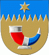
The drinking horn depicting coat of arms of Hämeenkyrö was designed by Gustaf von Numers and it was confirmed in 1954. After the wars, the evacuated Karelian population from Otradnoye (Pyhäjärvi) was mostly settled in Hämeenkyrö.
Results of the 2021 Finnish municipal elections, resulted in the True Finns being the largest group on the Hämeenkyrö council, in Hämeenkyrö.
The name Hämeenkyrö comes from Finnish words "Häme" and "kyrö", which together mean a craggy and thicketed area located in the Tavastia region.
The private coach company OnniBus route Helsinki—Seinäjoki—Vaasa has a stop at Hämeenkyrö.
Map - Hämeenkyrö
Map


Country - Finland
 |
 |
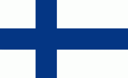
| Flag of Finland | |
Finland was first inhabited around 9000 BC after the Last Glacial Period. The Stone Age introduced several different ceramic styles and cultures. The Bronze Age and Iron Age were characterized by contacts with other cultures in Fennoscandia and the Baltic region. From the late 13th century, Finland became a part of Sweden as a consequence of the Northern Crusades. In 1809, as a result of the Finnish War, Finland became part of the Russian Empire as the autonomous Grand Duchy of Finland, during which Finnish art flourished and the idea of independence began to take hold. In 1906, Finland became the first European state to grant universal suffrage, and the first in the world to give all adult citizens the right to run for public office. After the 1917 Russian Revolution, Finland declared independence from Russia. In 1918, the fledgling state was divided by the Finnish Civil War. During World War II, Finland fought the Soviet Union in the Winter War and the Continuation War, and Nazi Germany in the Lapland War. It subsequently lost parts of its territory, but maintained its independence.
Currency / Language
| ISO | Currency | Symbol | Significant figures |
|---|---|---|---|
| EUR | Euro | € | 2 |
| ISO | Language |
|---|---|
| FI | Finnish language |
| SV | Swedish language |
